Kurzes Update von Mir:
Sehr viele schöne Zellen zu genüge, mit massig Graupel im Gepäck. Ausführlicher Bericht folgt.
Mfg Peter via Tapatalk


Kurzes Update von Mir:
Sehr viele schöne Zellen zu genüge, mit massig Graupel im Gepäck. Ausführlicher Bericht folgt.
Mfg Peter via Tapatalk
ZitatAlles anzeigenStorm Forecast
Valid: Tue 26 Apr 2016 06:00 to Wed 27 Apr 2016 06:00 UTC
Issued: Mon 25 Apr 2016 23:08
Forecaster: DAFIS
A level 1 was issued for Germany mainly for large amounts of small hail, severe wind gusts and tornadoes.
SYNOPSIS and DISCUSSION
A
cold arctic blast takes place over North Europe, where a dry air mass
intrudes into the continental parts from the North Sea. This event
results in cyclogenesis between SE Norway and the UK, and the cyclonic
vortex will be found over North Germany by the end of this outlook.
QG-lift is expected during almost the whole day tomorrow over the level 1
area, where low-topped convective cells will produce numerous of
lightnings especially during the maximum heat on the surface, thus after
12z. These storms could produce mostly sub-severe hail and/or graupel
but in large quantities they pose a threat, as the 0-3km will be in the
range of 10-15 m/s. Moreover, LLS is forecast to exceed the 10 m/s
locally in central Germany and combined with low LCLs, steep lapse rates
and SREH0-1km, there is a chance of tornadogenesis within the most
active storm cells. Waterspouts cannot be excluded at the coasts of
Germany, Denmark and Croatia due to LLCAPE and steep lapse rates near
the 1-2km from the surface.
Isolated thunderstorms are also
forecast at many other regions of Europe, with the most active ones in
NE Greece and NW Turkey, mostly during the morning of Tuesday.
Afterwards, diurnal heating will lead the convection in continental
parts of Turkey.
Quelle: www.estofex.org
Aktuell bei Bad Langensalza: 
Ich empfehle die heranziehenden Staffeln und Zellen im Westen abzufangen. Nach Osten hin scheint absinken und somit Abschwächung zu wirken.
Gesendet von Markus via Tapatalk
Noch schnell 2 Bilder vom Highlight des heutigen Tages. Zelle mit Böenfront und genialer Rückansicht, vor ca 45 Minuten in der Nähe von HIG.
P.s.: Das wird ein großer Bericht.
Mfg Peter via Tapatalk


Vorhin bei Heiligenstadt
Gesendet von iPhone mit Tapatalk
Rückseite der Zelle zw Gotha und Erfurt: 
Lasse mich gerade vom Cluster bei Eisenach überrollen. Wenigstens schon mal Donner gehört.
Gesendet von Markus via Tapatalk
Leipzig aktuell mit Blickrichtung NO-O

Gesendet von Maurice via Tapatalk


Schönste Schauerstimmung gerade
Gesendet von iPhone mit Tapatalk
Hier ein paar Bilder von mir zur heutigen Kaltluftschauersituation aus LK Söm und Kyf
LG Andreas
Schnell 3 bearbeitete Bilder von heute (Bad Langensalza/Eisenach):
VG
Markus
Ich war heute auf der Fahner Höhe und habe zwei Schauer fotografiert. Hier schnell ein paar Bilder:
Auf der Rückfahrt nach Jena an der A4-Ausfahrt Erfurt Ost:
LG Marco
Wie Rüdiger habe auch ich ein paar winterliche Impressionen zu bieten.
Gehlberg max. Schneehöhe 12cm
Frühs gegen 7.45 Uhr
Mittags nach Schauerdurchzug
Und die Sonnenseite.
WOW! Ihr habt ja richtig etwas zu sehen bekommen.
Am Harzrand sah es eigentlich wie immer aus:
Alle Tage wieder
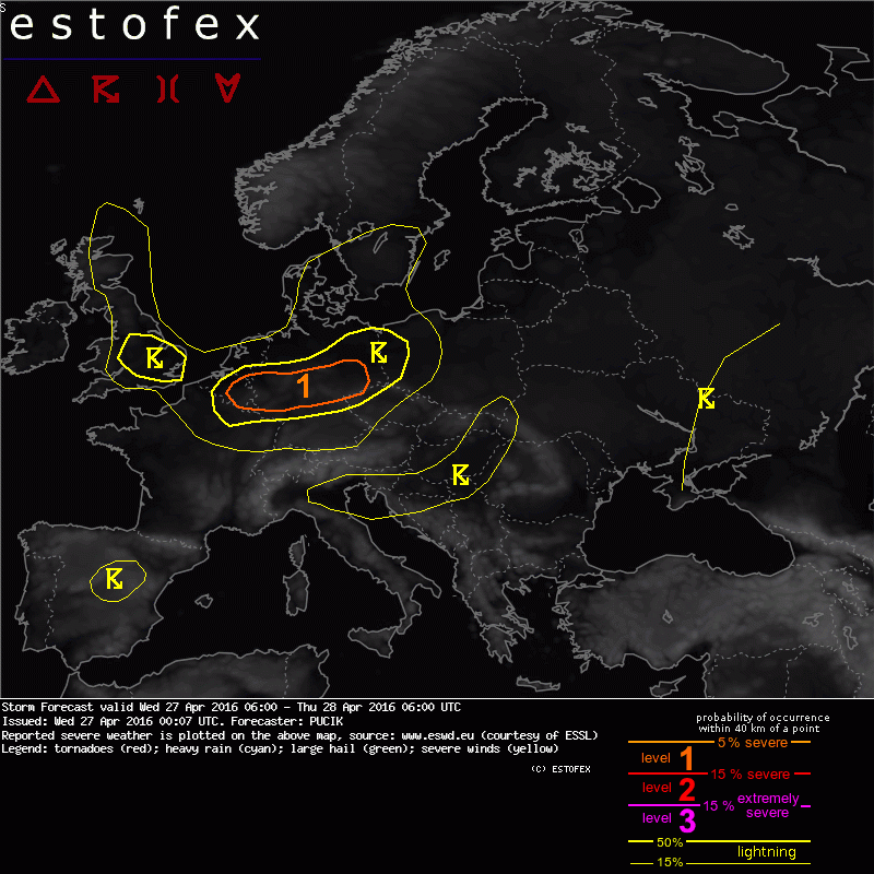
A level 1 was issued for eastern Belgium and central Germany mainly for severe wind gusts.
SYNOPSIS and DISCUSSION
Situation over whole Europe is dominated by a large mid to upper tropospheric low centered over Denmark. Unseasonably cold airmass has been advected from the Artic through Great Britain towards central Europe. Core of the low is associated with steep lapse rates reaching 7 to 7.5 K/km from surface to approximately 500 hPa, as is evidenced by numerous Tuesday 12 UTC soundings from NW Germany and UK. Also during Wednesday, scattered low topped DMC will form in bands and a rather large area of western to central Europe deserves at least a low prob lightning area. Despite the steep lapse rates, instability will stay marginal due to the meager mixing ratios up to 4 g/kg. A lvl 1 is introduced for parts of Germany and Belgium, where a belt of 850 hPa flow up to 20 m/s may contribute to severe wind gusts at the surface with any stronger downdraft. Otherwise, sub-severe hail / soft hail and gusty winds will be common in this situation.
Gesendet von meinem SM-G900FD mit Tapatalk
ZitatA level 1 was issued for eastern Belgium and central Germany mainly for severe wind gusts.
In der Level 1 Area ist primär mit konvektiven Böen im Abwindbereich der Zellen zu rechnen.
Auf ein Neues!
Gesendet von Markus via Tapatalk
Auf Wunsch eines einzelnen ![]() hier noch ein Bild von heute vormittag:
hier noch ein Bild von heute vormittag:
Den ganzen Vormittag schneite es. gegen 10 Uhr war es dann auch kalt genug, der Schnee blieb liegen, auch auf den Straßen.
Lt. Nachbar war auf der Bundesstraße nach Braunlage hinauf ein kleines Verkehrschaos entstanden, da die Straße nicht geräumt wurde.
Mehrere Autofahrer kamen ins Rutschen, passiert sei aber nichts.
Gegen mittag kam für eine halbe Stunde die Sonne durch, seitdem schneit es ununterbrochen, bleibt aber nicht mehr liegen, da es mittlerweile 7° "warm" ist.
Aktuell in 99718 vom gewohnten Platz
LG Andreas
Heute gegen 17:45 Uhr. Naja, nichts besonderes, aber immerhin etwas ![]()
Der Wohnblock stört jedesmal, kann denn mal jemand entfernen? ![]()