

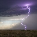
Ein super Beispiel für einen Fakenado! Klasse Bild!
Beiträge von Markus
-
-
Buchempfehlung: Hank Schyma "Pecos Hank" - Storm: Chasing Nature's Wildest Weather
Veröffentlichung: Ende Oktober 2025
Darauf kann man sich freuen! Ein wissenschaftliches Buch mit 256 Seiten wie Gewitter funktionieren, tropische Wirbelstürme, Blitze, Chasing-Tips und vieles mehr - im Erzählstil und mit Bildern von Hank. Mit Unterstützung von Dr. Anton Seimon, Tom Warner und Paul Smith.
Vorschau mit einzelnen Seiten auf Amazon: https://www.amazon.de/-/en/dp/024177…_fed_asin_title
-
Wir hatten schon Polarlichter, Leuchtende Nachtwolken, schöne Sonnenuntergänge oder Abendstimmungen. Aber bei keiner Tour sind wir durch das Gewitter zum Abschluss geflogen. Mehrmals wurde das Flugzeug von Blitzen getroffen. Die ersten zwei Mal sah man nur ein Aufleuchten und einen dumpfen Knall. Es gab einige Turbulenzen, die aber für mein empfinden nicht wirklich schlimm waren. Interstates fühlen sich in den USA teilweise nicht anders an.
Die weiteren Male konnte ich die Einschläge in den Flügel festhalten. Absolut faszinierend, wie sich der Blitzkanal mit dem Flugzeug mit bewegt und ein Streifen entsteht. Bitte schaut euch das Video an. Das hätte von mir aus Stunden so gehen können. Was für ein Spaß.
Ich hatte nach passenden Schlussworten für die Tour gesucht. Es endete mit Feuerwerk. Punkt.
20250612_lightning_airplanem.mp4
Es dürfte dieser Cluster gewesen sein:
-
10.06.2025 Great Sand Dunes National Park
Vom „Land of Enchantment“ ins Colorful Colorado. Always take the scenic route! Die Great Sand Dunes sind das Ziel des Tages. 6 Stunden von Roswell.
Auf der Strecke kommen wir auch mal durch Gegenden, wo wir bisher noch nicht waren. Zum Beispiel durch Santa Fe. Was für ein Unterschied in der Bauweise der Gebäude und der Landschaft. Sind wir irgendwo falsch nach Spanien abgebogen? Ähnlich geht es auf der Fahrt nach Norden weiter. Die mexikanische Prägung ist unverkennbar. In Española halten wir zum Mittagessen. Vermutlich das letzte BBQ.
Weiter nach Norden gewinnen wir auch an Höhe und sind zw. 1.500 und 2.400 Höhenmetern unterwegs. Wo Berge, da Konvektion.
In Alamosa checken wir im Motel ein. Für Felix, Thomas und mich geht’s gleich weiter in die Sanddünen.
Unterwegs, wie soll es auch anders sein, Staubteufel. Hier rotiert eben auch immer was.
Dazu Gewitter und Mammatus. Es bleibt ein Gewitter-Wunderland.
Vom Parkplatz aus laufen wir in die Sanddünen. Schaffen wir es bis ganz oben? Wir lassen es mal offen. Die Fitness ist schließlich nach drei Wochen sitzen nicht mehr bei allen auf den Stand wie bei Reisebeginn 😉
Wir haben mal wieder Glück. Durch die Schauer und Gewitter gibt es stundenlang Mammatuswolken. Das ist doch mal was in Kombination mit den Sanddünen.
Zwei steile Anstiege im Sand haben es in sich. Felix bezieht seinen Posten auf eine der unteren Dünen. Thomas und ich gehen weiter.
Als wir den zweiten Aufstieg hinter uns haben, eröffnet sich der Blick auf die riesigen und weiten Sanddünen vor der Bergkulisse? Was ist das bitte für ein grandioser Anblick?
Wir gehen auf die höchste Düne und bleiben dort bis zum Sonnenuntergang. Neben uns ein belgischer Storm Chaser, mit dem wir unsere Erlebnisse der letzten Wochen austauschen.
Die Bewölkung lässt leider nicht viel Licht auf die Dünen zu. Wohl aber auf die andere Seite, die schön angeleuchtet ist.
Die Dünen sind faszinierend anzusehen. Wir müssen immer wieder Bilder machen:
Die Sonne hat nur kurze Zeitfenster und wird von hohen Wolken getrübt. Das beste Abendlich wird es nicht mehr, aber wir haben heute die beste Entscheidung getroffen, hier hoch zu laufen. Welch ein Anblick!
Als die Sonne untergegangen ist, laufen wir zurück und kehren zufrieden ins Motel zurück. Das hat noch einmal richtig gut getan.
11.06.2025 Cottonwood Pass und Fahrt nach Denver
Eine Fahrt durch Colorado’s Berge mit Wäldern, Seen und Schnee ist ein würdiger und beruhigender Abschluss der diesjährigen Tour.
Von Alamosa aus machen wir einen Abstecher auf den Cottonwood Pass. Frische Luft und Schnee, es wirkt irgendwie reinigend nach den letzten Tagen hier oben auf knapp 3.700 Metern Höhe. Ein letztes Mal mexikanisches Essen in Leadville und dann geht’s noch einmal in den Walmart für Mitbringsel. Letzte Station Hotel am Flughafen. Auto ausräumen und Koffer einräumen. Noch einmal zusammen in den Videos der vergangenen Tage schauen. Kopfschütteln und lachen.
-
Unsere letzten Tage der diesjährigen Tour stehen an. Am Mittwochabend sollten wir in Denver sein, denn unser Flug geht am Donnerstag. Bis dahin ist noch Chasing oder Sightseeing möglich.
Gewitter gibt’s hier ja bekanntlich immer. Aber für uns ungünstig ist die fortschreitende Verlagerung der besseren Gewitteroptionen nach Süden bis nach Fort Stockton. Das ist uns zu weit wegen der anstehenden Rückfahrt nach Denver. Das wären von dort unten 11 Stunden.
Wir wählen die Gewitterauslöse über den Bergen New Mexicos und Colorados. Am Nachmittag und Abend gibt’s Tendenzen zur Linienbildung. Davor noch ein paar einzelne Zellen. Mangels Antrieb und Scherung aus der Höhe sind das aber eher „Standardgewitter“. Vielleicht gibt’s ja noch schöne Abendstimmungen. Eine weitere Option mit Superzellen wäre die Region bei Midland in Texas. Da die Zellen aber ebenfalls noch weiter nach Südosten ziehen, wäre auch das zu weit.
In Vaughn stellen wir uns bereit und warten. Dazu etwas Züge gucken.
Dann fahren wir mal ein Stück der ersten Zelle entgegen. Südlich von Corona (ja, der Ort heißt so) können wir dem Treiben etwas zuschauen.
Als sich ein neuer Aufwind bildet gibt es kurzzeitig einen horizontalen Funnel. Und später vermutlich nochmal einen. Bei dieser Pampe, sinnlos, aber geil.
Bild: Thomas KleinDie Routenoptionen lassen uns nur zwei Möglichkeiten für die spätere Linie zu. Entweder zurück nach Norden und dann nach Süden oder jetzt nach Süden und wieder nach Westen. Wir wählen heute Variante 2.
Das dauert ein bisschen, ist aber ziemlich scenic. Die Weite, Leere und Stille New Mexicos in diesem Bereich nicht auf Bildern darstellbar. Aber auch die Armut in den kleinen Orten.
Besagte Linie ist nun unterwegs, jedoch wesentlich nördlicher als angenommen. Wir quartieren uns in Roswell ein. Von der Linie haben wir hier nichts mehr. Später gibt’s noch eine neue Zelle direkt über uns. Das obligatorische Abendgewitter halt.
Zufriedener können wir von den Vortagen sowieso nicht sein. Ab morgen gibt es dann Natur-Sightseeing auf dem Weg zurück nach Denver. Juhuuuuuuuuuuuuuuu!
-
Zwei aufregende Tage liegen hinter uns. So intensiv, dass wir schon gar nicht mehr alles von den Tagen zuvor wissen. Die Tage sind lang und es passiert so viel, dass der Kopf zwar aufnimmt, aber nicht alles verarbeitet. Unter einer sehr schnellen Mesozyklone als sie sich entwickelt, neben einem großen Wedge-Tornado, dann in einem Wirbel, dann weitere Tornados, Struktur, Mutterschiff, Burger und Pancakes. Puh.
Der 07. Juni ist ein Verlagerungstag nach Norden für die Lage am Folgetag (08. Juni). Die Modelle haben auch für heute eine einzelne Zelle im Programm, die quer durch das Panhandle zieht. Wir lassen erst die Option offen, verwerfen sie aber dann zugunsten der Regeneration. Wir wählen Pampa in Texas für die Übernachtung. Im Pool entspannen und später Burger essen. Zum Abendessen tauchen die ersten Bilder der Zelle auf. Struktur im Abendlicht – und das nicht zu knapp. Wir haben uns heute anders entschieden.
Für den heutigen Chasingtag (08. Juni) stehen mal wieder mehrere Optionen zur Auswahl. Im Panhandle kann es im nördlichen Bereich diskrete Zellen geben, wie auch im östlichen Panhandle oder südlicher in Texas. Im östlichen Panhandle und südlich wird sich später eine große Gewitterlinie entwickeln. Das ist für uns eher weniger interessant. Wir wählen das nördliche Oklahoma/Texas-Panhandle (blauer Kreis). Dort sind die Bedingungen unmittelbar vor der Kaltfront noch am besten für langlebige, diskrete Zellen.
Wir fahren erstmal nach Guymon. Östlich von uns blubbern seit den Vormittagsstunden Zellen an der Outflow Boundary. Von diesen darf man sich nicht triggern lassen, nur weil sie schon da sind und die Mesoscale Discussion des SPC diese auch im Verlauf als Option für tornadische Superzellen sieht, sobald sie aus der Grundschicht zutschen (ihr kennt das Geräusch dazu😉).
Der Himmel sieht schon mal vielversprechend aus:
Bild: Thomas KleinNördlich von uns, bei Elkhart, bildet sich eine erste einzelne Zelle. Die fahren wir mal an. Auf der Fahrt bildet sich rasch eine weitere weiter westlich bei Boise City. Diese sieht robuster aus. Wir fahren gleich dort hin weiter.
Während der Fahrt können wir die Entwicklung einer Wallcloud beobachten.
Wir müssen die Taktik zur Anfahrt kurz vor der Zelle anpassen. Entweder eher nach Süden und wieder nach Westen, um davor zu bleiben oder es reicht noch knapp daran vorbei zu fahren und sich dann weiter nach Süden zu positionieren. Ich persönlich favorisiere die zweite Variante. Die Zelle ist noch weiter in der Entwicklung. Niederschlag ist kein Problem und so schnell kommt noch kein Tornado. Weiterer Vorteil: Wir stehen auf der Rückseite im guten Licht.
Wir halten mit etwas Abstand zur Zelle am Straßenrand. Wir sind komplett alleine hier. Keine anderen Chaser sind da. Keine Locals. Kein Verkehr auf Straße. Es herrscht Stille. Ein paar Vögel zwitschern. Entspannung.
Nach ein paar Minuten sagt der Erste „Ist das ein Funnel“? Alle schauen hin, fokussieren mit den Augen den Rand und tatsächlich: Es rotiert! Es ist wirklich ein Funnel.
Hatten wir in den letzten Tagen oftmals zuerst Aufwirbelungen am Boden und keinen Trichter aus der Wolke, ist es diesmal genau andersherum. Und das Ding wächst noch weiter nach unten!
Jetzt beginnt es unglaubwürdig zu werden.
Wir können es nicht fassen, was hier vor uns geschieht. In dieser absoluten Leere formt sich dieser Tornado ganz sanft nach unten. Still und anmutig. Ein Traum könnte es nicht besser darstellen. Und dann ist er da:
Positiv geschockt und nicht begreifend, was sich hier abspielt stehen wir angewurzelt da und saugen diesen wunderschönen Tornado in uns auf. Ich hatte kurz Bedenken, dass er zu nah kommt, aber er zieht in ca. einem Kilometer an uns vorbei. Wir können bleiben.
Der RFD kommt nun mit Windböen und ein paar Tropfen. Er möchte einen leichten Vorhang vor den Tornado ziehen. Das lassen wir bestimmt nicht zu. Schnell ins Auto und ein paar Meter weiter.
So still wie die Szenerie waren auch wir alle. Alle haben gefesselt zugeschaut und den Moment genossen. Erst im Auto entlädt sich ganz kurz das Emotionsgewitter.
Er ist immer noch da. Wir realisieren die Zeit gar nicht mehr. Von uns aus kann es noch lange so weiter gehen. Er ist über der Prärie im Nirgendwo.
Wir können einige Minuten stehen, ehe wieder der rückseitige Abwind (RFD) mit Wind und Regen zunimmt.
Ein letztes Mal ein paar Meter weiter. Währenddessen hat er seine Zeit überschritten und geht ins Roping out (er löst sich auf). Und dieser Moment kann noch einmal dahingehend spannend werden, weil der Bodenwirbel doch nah bei uns sein kann. Die vertikale Säule wird nun wieder in die Horizontale gebracht.
Und plötzlich ist er statt eines Kegels ein langer, schmaler, filigraner Schlauch. Diesen Anblick hatte keiner von uns bisher so nah. In diesem dünnen Schlauch sehen wir ein wildes, rasantes wirbeln. Ein Schleudergang der den Boden nach oben in die Wolke saugt. Hypnotisierend.
Und der Bodenwirbel kommt wirklich rechts neben uns auf dem Feld in unsere Richtung. Wir fahren nochmal vor. In der kurzen Zeit ist er dann vollständig verschwunden.
Bilder (3): Thomas KleinRadarloop:
Durchatmen. Was war das bitte?
Jetzt kommt der Teil, wo das fokussierte Funktionieren im Kopf sich mit dem emotionalen Übereindrücken mischt. Die Augen sind groß, „holy shit“, „Alter!“, Kopfschütteln, „wir müssen weiter“, „die probierts nochmal“, schnelles gucken auf dem Handy oder der Kamera.
Nur wenige haben ihn gesehen. In Anbetracht der riesigen Chaserkonvergenz an manchen Tagen ein zusätzliches Geschenk.
Neupositionierung etwas weiter südlich am Straßenrand. Mit Abstand im Sinne der Distanz schaltet der Kopf auch kurz auf emotionalen Abstand. Eine Teamumarmung zur Feier! Was für ein Erlebnis! Für alle ist es ein besonderer Moment und ein Highlight fürs Leben.
Die Realität holt uns aber schnell ein. Ein dumpfer Aufschlag in unserem Umfeld. Noch einer. Hagel! Nicht jener der kleinen Sorte. Sofort wird zusammengepackt. Denn diese einzelnen Teile fallen direkt aus dem rotierenden Aufwind. Einerseits ein gutes Zeichen dafür, dass der Aufwind noch funktioniert und stark ist, andererseits schlecht weil es weh tun kann.
Neuen Abstand gewinnen. Wir sind weiter alleine. Unsere Zelle möchte wieder neuen Anlauf nehmen. Sie organisiert sich neu, Inflow kommt dazu, Wallcloud bildet sich.
Der neue Zyklus hat begonnen. Sie ist aber noch nicht bereit den nächsten Tornado zu bilden. Das gibt uns Zeit weiter nach Süden zu fahren, denn die Straßenoptionen werden etwas dünner und wir möchten gern davor bleiben.
Als wir den nächsten Halt erreichen, ist für wenige Sekunden ein Wirbel nur am Boden sichtbar und genauso schnell weg wie er da war. Da geht aber noch was.
Bilder (3): Thomas KleinÜber trockene Feldwege geht’s nun weiter nach Süden. Die Straße ist stark von LKW’s befahren. Viel Staub, Ersatz für die Chaserkonvergenz heute – haha.
Während der ersten Meilen ist die Zelle wieder soweit. Wir sehen wieder einen Funnel links neben uns. Und dann ist er am Boden. Etwas schwierig hier zu halten. An einer Einfahrt klappt es.
Bilder (4): Thomas KleinWieder ein Erfolg. Und mit der Whales Mouth Struktur darüber auch etwas, was wir bisher noch nicht gesehen haben.
Bild: Thomas KleinEs dauert eine Weile, bis wir wieder auf befestigter Straße sind. Meilen müssen erstmal gut gemacht werden, um sie auf ihren Südostkurs abzufangen.
In der Zeit verpassen wir nichts. Am nächsten Halt hat sie sich wieder neu organisiert. In der Ferne ist kurz ein Funnel zu erkennen.
Bild: Thomas KleinWir fahren wieder weiter als der Outflow bei uns ankommt.
Bild: Thomas KleinAuf der Fahrt fällt nun immer mehr die Abwinddominanz auf. Das ging dann doch recht schnell. Wir checken erstmal die Lage. Unsere Superzelle wird in Kürze von dem großen Cluster östlich von uns mit „gefressen“. Damit ist an dieser Stelle auch Schluss mit der Jagd. Wir quartieren uns in Tucumcari ein. Haben wir uns heute was verdient! Mexikanisch wird in einem Restaurant in der Stadt gegessen.
Was fehlt noch? Richtig, das obligatorische Abendgewitter. Ist bereits da. Thomas und Felix schauen vom Motel-Parkplatz noch etwas zu. Andre und ich schauen die Videos des Tornados an. Nur zur Vorsicht, ob auch alles wirklich passiert ist 😉
Es ist aber wirklich passiert. Wir haben die beste Zelle des Tages erwischt mit einem fotogenen Tornado über offenem Land. Nun haben auch Andre, Felix und Thomas ihr persönliches „Milnesand“. Hätte ich 2015 nicht dieses überwältigende Ereignis gehabt, wäre dieser Tag die neue Nummer 1. Unabhängig von diesem Ranking sind wir alle stolz, glücklich und demütig. Und sicher noch etwas überdreht. Ohne Erwartung oder nur der geringsten Ahnung was uns heute erwarten wird, sind wir in den Tag gestartet. Wie auch schon 2015 in Milnesand. So entstehen Momente fürs Leben.
Und nach drei intensiven Tagen nach fast 3 Wochen sieht man es uns vermutlich auch an

-
Es braucht mehrere Dinge für einen Tornadotag:
- Stratus
- Nieselregen
- Geruch nach Scheiße in der Luft (wer Teile Texas' kennt weiß was wir meinen)
- alle tragen die gleichen T-Shirts
- ein Maskottchen
- gutes Essen
Es stehen für heute drei Targets zur Auswahl. Für eins müssen wir uns entscheiden. Die Distanz zwischen den Targets lässt es nicht zu, nochmal zu wechseln.
Target 1: Südwest-Kansas/Südost-Colorado: Colorado Magic in den High Plains. An der Warmfront eines kleinen Tiefs wird es Superzellen und Tornados geben. Gute Sicht, kein Staub, moderate Chaserkonvergenz.
Target 2: Ost-New Mexico/West-Texas Panhandle: Östlich der Dryline wird es zünden und Superzellen werden an einer Outflow-Boundary ostwärts ziehen. Diese bringt den nötigen „Spin“ für große Dinge. Später HP-Modus und viel Staub. Große Chaserkonvergenz.
Target 3: It’s always Fort Stockton or Bust! Diskrete Zellen aus den Davies Mountains ziehen ostwärts. Geringstes Tornadopotential. Wenige Chaser.
Noch am Vorabend war ich persönlich bei Target 1. Auch im Hinblick für die Lage am nächsten Tag in dieser Region. Am Morgen des 05. Juni war allerdings klar, dass Target 2 der Tornado-Bringer werden wird. Eine Zündschnur wie diese Outflow Boundary kann man nicht liegen lassen. Daher heute Dienstkleidung für alle

Der Tag beginnt bereits vielversprechend: Kühl, dichter Stratus und Nieselregen. Ein sicherer Anhaltspunkt für einen Tornado-Tag. Das ist keine Ironie! Und das Target ist nicht mal schwierig zu finden: An bzw. leicht nördlich der Outflow Boundary positionieren und auf Zündung warten.
Wir visieren erstmal Lamesa im Süden an. Dort tanken wir Auto und Mägen nochmal auf, denn heute wird es spät werden. Im mexikanischen Restaurant haben drei Dollar gereicht, um aus einem Automaten unser diesjähriges Maskottchen zu greifen: George (gesprochen „Hoche“).
Ein Blick in die Mesoanalyse zeigt uns, dass wir uns besser etwas nördlicher positionieren sollten. Also zurück nach Brownfield. An der dortigen Tankstelle sind wir nicht alleine. Die Fahrzeuge des ICECHIP Forschungsprojektes haben neben anderen Chasern bereits den Parkplatz eingenommen. Dazu bester Tornadohimmel.
Wir treffen Tim Marshall, der uns ein bisschen was über das Projekt erzählt und die Hageldellen im Auto zeigt. Ebenso „Dummies“ von Dächern im Kastenaufbau des Fahrzeugs. Das Ziel ist es, direkt in den Hagel zu fahren. Das würde uns auch Spaß machen. Ab 10cm Durchmesser wird es richtig gefährlich im Auto, sagt Tim.
Im östlichen New Mexico entwickeln sich nun zwei Zellen.
Die Forschungsteams brechen auf, die Chaser kurz danach, wir bleiben noch stehen. Es deutet sich aber an, dass diese Zellen der Deal des Tages werden. Also fahren auch wir los. Diesmal am Ende der Lichterkette. Das hat den Vorteil, dass wir dann die Ersten sind, wenn wir wieder los fahren müssen.
Während der Anfahrt verstärkt sich die südliche Zelle. Als wir näher kommen, ist bereits eine ausgeprägte Wallcloud sichtbar.
Da die Zelle auf uns zuzieht, halten wir mit Abstand für Struktur und Tornado. Es dauert vielleicht eine Minute und der erste Staub ist auf dem Boden erkennbar, Darüber auch eine Säule. Tornado Nr. 1!
Bilder (2): Thomas Klein
Die schnelle Rotation und große Wallcloud signalisieren bereits, dass hier noch viel passieren wird. Wenige Minuten vergehen und der nächste Tornado ist da. Diesmal mit schöner Form. Nr. 2. Woran man Tornadogenesis auch erkennt: Der Inflow legt massiv zu kurz bevor es losgeht.
Bilder (2): Thomas Klein
Und danach gibt’s den nächsten mit Staubfuß. Nr. 3.:
Bild: Thomas Klein
Im Anschluss wieder eine lange Funnel Cloud:
Moment, auch da ist irgendein Wirbel rechts am Boden. Der nächste! Nr. 4!
Nach diesen ersten Versuchen findet erstmal eine kurze Re-Organisation statt. Auch wir verlagern uns wieder etwas ostwärts. Wir halten kurz und schauen der neuen Wallcloud direkt neben uns zu. Es wird wohl nicht lange dauern.
Noch ein kleines Stück vor und aus dem Inflow-Staub-Sturm raus.
Bild: Thomas Klein
Zu diesem Zeitpunkt bildet sich unter der Wallcloud ein größerer Tornado. Wir realisieren noch gar nicht, dass gleich neben uns ein großer Wedge-Tornado sein wird (Wedge = Keilform).
Als die Kante sichtbar wird, können wir es kaum glauben. Was für ein riesiges Teil! Eine gigantische rotierende Staubtrommel auf dem Boden. Tornado Nr. 5. Wedge Nr. 1.
Bild: Thomas Klein
Bild: Thomas Klein
Wir müssen weiter - wenn wir denn gelassen werden. Die Lichterkette gibt uns keinen Platz. Ein freundlicher Chaser lässt uns dann aber rein. Wie üblich möchten wir erstmal Abstand gewinnen und dann eine Weile zuschauen. Touch and go (für die Insider - haha).
Bild: Thomas Klein
Nach einer interessanten Fahrt über Feldwege gelangen wir wieder vor die Zelle. Kurzes Bild von einem Zwischenhalt:
Bild: Thomas Klein
Eine mystische Stimmung erwartet uns am nächsten Halt. Die Superzelle ist so hoch und mächtig, dass es dunkel wird als bricht die Nacht ein. Dazu Geflacker, Donner und Staub, der zur Zelle gezogen wird.
Bild: Thomas Klein
Wir müssen wieder weiter. Die Superzelle ist sehr groß und zieht recht schnell. Wir müssen auch bedenken, dass sie Kurs auf Lubbock nimmt. Das ist für die Stadt sehr schlecht. Ein Tornado in solch einer großen Stadt ist der Worst Case. Aber auch ohne gibt es großen Hagel, ergiebigen Starkregen und kräftige Windböen über 100 km/h. Unsere Probleme dagegen sind eher marginal. Wir müssen einfach vor der Zelle bleiben und die Stadt umfahren.
Zuerst halten wir aber nochmal für die Strukturbilder. Da diese riesige Superzelle enormen Inflow hat und die Felder trocken sind, kommt als Challenge dazu, etwas staubgeschützt zu stehen. Grüße an Christoph Geissler – es wäre ein großer Tag für dich gewesen!
Im „Inflow-Lee“ eines Pferdestalls klappt es. Vor uns: Das Mutterschiff:
Bild: Thomas Klein
Inspiriert von unserer Staub-Sand-Strahlung am ersten Tag in Colorado gönnt sich Felix auf dem Feldweg nochmal die volle Inflow-Dröhnung. Im Hintergrund heulen die Sirenen aufgrund der Tornadowarnung. Welch eine Stimmung. Es handelt sich immer noch um die gleiche Zelle. Mehrere Tornados, darunter ein großer Wedge, jetzt noch das Mutterschiff. Was kommt denn bitte heute noch alles?
Wir verlagern uns über den Norden von Lubbock auf die Ostseite und warten ab.
Wir stehen unter einem breiten Inflow-Band. Vor uns hohe Blitzfrequenzen. Die Sirenen heulen ununterbrochen.
Da wir nicht viel sehen, fahren wir nun nach Südwesten. Unsere Superzelle verlagert sich nun deutlich nach Südosten. Wir möchten auf die Südseite mit freier Sicht. Das dauert etwas. Es ist noch eine Stunde Zeit bis Sonnenuntergang. Wo die Superzelle ist, ist es tiefschwarz wie in der Nacht.
Glücklicherweise gab es in Lubbock keinen Tornado. Schäden durch Starkregen, Hagel und Wind aber allemal.
Als wir wieder Platz haben, sehen wir etwas mehr Dominanz des Abwinds. Der MCS-Mode ist on. Es ist dennoch fotogen. Und wie in Nebraska vor wenigen Tagen haut es hier wieder böse Erdblitze raus. Einer ist recht nah. Wir gehen mal ins Auto und fahren weiter.
Videostandbild: Thomas Klein
Das südliche Ende macht noch einmal etwas Rotation. Wir stehen ein letztes Mal davor. Dann entscheiden wir uns für das Ende der Jagd.
Zurück nach Lubbock für die Nacht. Unterwegs gibt’s noch eine mystische Stimmung, die auf den Fotos nur schwer einzufangen war.
Und tatsächlich kommt eine weitere Superzelle aus der gleichen Region der ersten auf uns zu! Es hört heute nicht auf. Unser Motel liegt aus unerklärlichen Gründen direkt in der Zugbahn.
Während wir versuchen mit Nachos das heutige Erlebnis zu verarbeiten zieht die Zelle knapp an uns vorbei. Viele Blitze, Regen und kleiner Hagel werden vom Wind durch die Gegend geschleudert. Das obligatorische Abendgewitter halt. Das Equipment ist voller Staub und Sand, die Kleidung ebenso, die Haare erst recht, das Auto – naja egal.Noch voller Eindrücke ist schlafen nicht so schnell möglich. Ein Tag der Superlativen. Was soll jetzt noch kommen?
-
Das waren zwei eindrückliche Tage in Norman. Übermorgen (02.06.) sieht es nach einer Lage in Nebraska aus. Das bedeutet auch eine längere Anfahrt. Aber zuerst gibt es noch Optionen in Oklahoma am späten Abend, die wir noch nicht ganz abschreiben wollen.
31.05.2025 Gedenkminute und Fahrt nach Norden
Zuerst geht es zur Gedenkstätte von Tim, Paul und Carl bei El Reno. Der Besuch und ein kurzes Gedenken sind ein Muss auf jeder Tour, insofern wir in der Gegend sind. In diesem Jahr sogar am Jahrestag, dem 31.05. Das war allerdings Zufall.
Bei unserer Verlagerung nach Norden wird deutlich, dass die abendliche Lage erst sehr spät starten wird. Die noch im Abendlicht auslösenden Zellen dürften eher unspektakulär sein und Nachtgewitter schließen wir aus. Also weiter.
01.06.2025 Fahrtag und Reifenprobleme
Kein Jahr ohne Reifenproblem. Der linke hintere Reifen hatte am letzten Morgen nur die Hälfte des Drucks. Nach etwas Luft an der Tankstelle blieb er konstant. Am nächsten Morgen ist er wieder unten. Da muss also doch was sein. Wir fahren in Lexington an eine Tankstelle mit integriertem Reifenservice. Dort wird innerhalb von 10 Minuten unser Reifen gefixt – ohne das wir was zahlen müssen. Natürlich gibt’s einen Tip (=Trinkgeld) für den unkomplizierten Service.
02.06.2025 Scenic Supercell in den Nebraska Sandhills
Nach einem entspannten Motel-Aufenthalt starten wir am 02.06. nordwärts. Kurze Mittagspause in Sumner und dann ab in die Bereitstellung in Ansley und auf Auslöse warten. Die ist heute sicher. Ebenso die Wartezeit von wenigstens 4 Stunden. Wir passen unser Target noch etwas nach Norden an und stationieren uns in Broken Bow. Hier klappt es einige Zeit später mit der Auslöse knapp nördlich von uns.
Die Fahrt durch die Sandhills ist landschaftlich betrachtet sehr schön. Viele Hügel und Hügelketten mit Gras, einzelnen Bäumen und den guten alten Windmühlen neben den neuen "Windmühlen".
Die schöne Gegend macht parken schwierig. Am Straßenrand geht nicht wirklich was und Einfahrten sind Mangelware. Wir finden eine passende Zufahrt und halten. Von hier sind wir direkt an der Versorgungslinie der ersten Zelle nördlich von uns bei Lillian. Die neuen Türme sehen vielversprechend aus.
Der Beginn:
Schirm nach Osten:
Die Weiterentwicklung:
Es wird immer besser:
Basis und Aufwind strukturieren sich weiter:
Und immer weiter:
Wir stehen genau richtig. Es ist trocken, wir haben ausreichend Abstand und sehen die gesamte Struktur von oben bis unten. Unsere Zelle macht sich nun immer besser und ist nahezu stationär. Der Anbau neuer Zellen erfolgt immer ein Stück weiter westlich. Es gibt ständige Erdblitze. Viele können wir fotografieren. Eine Auswahl:
Bilder (3): Thomas Klein
An diesem Standort konnten wir gute 45 Minuten stehen und Gewitter genießen. Keine Chaserkonvergenz! Die mag ich mir hier gar nicht vorstellen. Nur einmal kam ein Auto mit lokalen Chasern vorbei. Und die konnten uns sogar auf deutsch begrüßen. Einer war zwei Jahre in Nürnberg. Als die Blitze wie die Zelle selbst näher kommen, müssen wir uns wieder südwärts verlagern.
Vor Broken Bow können wir nochmal halten. Es wird nun immer mehr ein linienartiger Modus wie erwartet. Aber längst nicht unfotogen:
Weiter geht’s nach Osten. Wir surfen im Grunde vor der Böenfront. Am nächsten Haltepunkt gibt es in unserer Nähe vorlaufend zwei sehr starke Blitze mit 144 und 111kA. Wir haben sie nur durch das aufleuchten bemerkt ohne einen Blitzkanal gesehen zu haben. Aber der Donner war abgrundtief düster als er über das ganze Gebiet rumpelte. Wir fahren doch mal wieder ein Stück weiter. Nebraska sehen und sterben – nicht heute.
Die nächste Standortsuche ist wieder etwas schwierig. Aber wir finden noch einmal einen schönen Punkt mit weiter Sicht. Inzwischen hat sich eine Gewitterlinie gebildet.
Da wir eh weiter nach Süden müssen, wollen wir uns noch vor die Linie setzen. In Ansley, wo wir heute schon mal standen, durchfahren wir die stärkste Zelle. Die Sicht ist teilweise auf wenige Meter herabgesetzt. Dazu kleinerer Hagel und sehr starke Windböen. Das Auto wackelt. Wir können nur Schrittgeschwindigkeit fahren. Der Regen kommt im Schleudergang quer über die Straße gefegt.
Hier ist wieder etwas Straße erkennbar:
Nachdem wir endlich aus diesen Bereich sind, entscheiden wir uns noch bis Hays für die Nacht zu fahren. So haben wir es am nächsten Tag kürzer und kommen rechtzeitig zur nächsten Lage an. Die wird schon am frühen Nachmittag im Norden von Oklahoma starten. Während der Fahrt gibt’s noch die üblichen Standard-Gewitter mit Geblitze und Regen. Und ein Reh auf der Straße, dass heute in Nebraska sterben wollte.
Am Ende haben alle überlebt.
-
Der heutige Tag wird ein großes Highlight werden. Zuerst nehmen wir uns am Vormittag Zeit für das National Weather Museum in Norman. Das hat nur von Freitag bis Sonntag geöffnet.
Hier kann man u.A. Tim Samaras‘ „The Big Kahuna“ Kamera bestaunen. Diese Kamera hatte Tim in den letzten Jahren vor seinem Tod im Jahr 2013 zur Blitzforschung im Einsatz.
Ebenso findet sich ein zerstörtes Fahrzeug in der Ausstellung. Es stammt vom letzten EF-5 Tornado vom 20. Mai 2013 aus Moore, einem Vorort von Oklahoma City.
Eine Mesonet-Wetterstation, verschiedene Drohnen und ein Flugzeug sind ebenso Bestandteil der Ausstellung.
Es gibt auch noch früher verwendete Technik zu sehen, ein paar Infos zur Geschichte und eine Bibliothek. Ein paar Eindrücke:
Am Nachmittag entspannen wir uns im Pool und gehen noch einmal wie am Vortag bei einem sehr guten Mexikaner essen.
Durch Felix‘ Kontakt zu einem sehr bekannten Meteorologen haben wir das Glück, an eine private Führung im National Weather Center in Norman zu kommen.
Die Tour gibt uns kein geringerer als Chris Broyles. Er ist als Meteorologe und Tornadoexperte bekannt und seit gut 30 Jahren im Dienst. Mit der „Silber-Medaille“ ist er in der Lobby verewigt für seine Vorhersage mit einem „Day 2 High Risk“ im Jahr 2006. Es war das erste jemals ausgegebene High Risk am 2. Tag. Zwei weitere von ihm sollten in der Zukunft noch folgen (2012 und 2025).
Wir merken schnell, welches Fachwissen und welcher Erfahrung er verfügt. Das ist sehr beeindruckend. Wir unterhalten uns über seine wichtigsten Momente in seiner Karriere als Vorhersager, welche zweifelsohne die High Risks sind. Dabei gibt er auch einige persönliche Eindrücke preis. Er hat in natura über 100 Tornados gesehen und geht auch selbst chasen wenn es möglich ist.
Wir erfahren viel über die Vorhersage im SPC (=Storm Prediction Center) und welche Kollegen wann was tun. An den Wänden finden sich Poster zu verschiedenen Forschungsthemen und Tafeln zur Geschichte des National Weather Centers und historischen Tornado Outbreaks.
Besonders beeindruckend ist auch die zur Zeit in Anwendung und weiterer Entwicklung befindliche Datenbasis und das Machine Learning in der Tornadovorhersage. So hat das Tool den Tornado in Plevna, Kansas am 18. Mai bereits 27 Stunden vorher simuliert.
Und in der Zukunft wird es sicher noch mehr beeindruckende Tools und Ergebnisse geben. Der technische Fortschritt kombiniert mit Menschen von hoher Fachexpertise wie Chris Broyles in Zusammenarbeit mit Cameron Nixon haben das Potential Dinge für die Zukunft zu verändern und neue Zeitmarker zu setzen.
-
Eine Woche ist vorbei. Wir nehmen uns zwei Tage Pause. Die Wetterlage am 29. Mai hätte zwar noch ein Chasing in Texas zugelassen, aber wir haben bereits Pläne und einen festen Termin.
Das Twister Movie Museum in Wakita haben einige von uns bereits (mehrfach) besucht. Der Film hat jeden Storm Chaser inspiriert. Nächstes Jahr wird er 30 Jahre alt.
Und so ist dieses Museum auch ein fester Ort, an den wir Chaser zurückkehren und unsere Spuren hinterlassen. Zum Beispiel mit eigenen T-Shirts, die im Museum an den Wänden hängen. Beim Besuch im letzten Jahr haben wir erfahren, dass es noch kein deutsches T-Shirt gibt. Das musste dringend geändert werden. Wie passend, dass wir ab diesem Jahr neue T-Shirts gedruckt haben. Solch ein Exemplar haben wir mit großer Freude an Linda, der Inhaberin, übergeben. Und somit sind wir das erste deutsche Team dort, dass sich mit einem T-Shirt verewigt hat.
Wir konnten uns mit Linda und ihrem Team noch einige Zeit unterhalten. Aus dem zweiten Teil des Films sind jetzt auch der Anhänger mit den gelben Fässern und Teile des Motels-Schilds zu finden.
Es wird also nie langweilig hier. Und jährlich gibt’s neue T-Shirts, von denen wir natürlich auch welche mitnehmen müssen.
Ein paar Eindrücke vom aktuellen Stand im Museum:
Zufrieden fahren wir weiter nach Norman für die erste Nacht.
Dort spielen wir noch einige Runden Thomas‘ selbst entwickeltes Kartenspiel „Build your Storm“. Wer Interesse am Spiel hat, meldet sich bitte bei Thomas.
-
Ich ergänze meine Bilder von diesem Tag.
Es war ein Fest an HP-Strukturen. Und eine Katastrophe hinsichtlich der Chaser-Konvergenz. Das war die schlimmste aller Touren bisher. Glücklicherweise waren wir ab der zweiten Hälfte des Chasing alleine oder nur von wenigen Chasern umgeben.
Wie es begann:
Die erste Zelle im ersten Superzellen-Zyklus bei Matador, TX:
Näher heran:
...und wieder ein Stück weiter. Es ist immer noch die selbe Zelle:
Nach dem Merge mit einer anderen Zelle:
Danach brachen wir aufgrund der üblen Chaser-Konvergenz ab und fuhren nach Aspermont. Wir waren hier vollständig alleine.
Weiter davor bleiben:
Der beste Zeitpunkt des Tages:
Danach Blitze ohne Ende:
-
Einmal bei jeder Tour geht es in den Südwesten von Texas ins Gebiet rund um Fort Stockton. So auch heute. Das Setup ist aber nicht vergleichbar mit den letzten beiden Tagen.
Aus dem Gebirge heraus ist am Nachmittag mit einzelnen Gewittern zu rechnen, die zum Abend verclustern sollen. Die Gefahren sind starke Windböen (trockene Grundschicht) und Hagel.
Zuerst gönnen wir uns in Ozona ein mexikanisches Frühstück in einem kleinen aber feinen Lokal. Dort frühstücken auch gerade der Sheriff und seine Deputies. Wir kommen ins Gespräch und welch Überraschung: Er kennt Deutschland. Und das nicht aus Nettigkeit, sondern weil er wirklich da war. Bad Brückenau, Fulda, Würzburg. Kenn wir doch auch! Na gut, Bad Brückenau eigentlich nicht.
Das Essen schmeckt uns so gut, dass wir noch Verpflegung für den Abend mitnehmen. Die Optionen sind südlich von Fort Stockton begrenzt und wir wissen nicht, ob wir abends länger draußen stehen (müssen).
Nach einiger Wartezeit löst es am Nachmittag über den Bergen aus. Die erste Zelle fahren wir an. Kaputt. Zurück. Die nächste ist etwas besser, wir bleiben dran und beobachten. Kaputt.
Jetzt erstmal abwarten was noch passiert. Drei Zellen sind von den Davies Mountains her eine Option. Da wir aber nur begrenzte Straßenoptionen haben, müssen wir gut abwägen. Wir entscheiden uns für die südlichste Zelle. Auf der Anfahrt splittet sie. Soweit noch alles gut.
Wir müssen uns wieder entscheiden. Aufgrund früherer örtlicher Erfahrungen und der allgemeinen Regel, die südlichere Zelle anzufahren, entscheiden wir uns für die Fahrt nach Marathon.
Doch was passiert? Unsere Zelle geht kaputt. Die beiden anderen Zellen westlich dümpeln vor sich hin. Wir fahren nach Fort Stockton zurück. Währenddessen schwächen sich auch die beiden anderen Zellen immer mehr ab. In Anbetracht der Lage an den Folgetagen im Panhandle (sieben Stunden Anfahrt) entscheiden wir uns die Jagd zu beenden.
Um etwas Strecke gut zu machen, fahren wir noch bis Seminole (Texas), begleitet von ein paar deutsch anmutenden Gewittern mit wenig Struktur und ein paar Blitzen. Sorry an alle zu Hause für diesen Satz 😊
-
Wann ist ein Chasing ein Erfolg? Es besteht aus Erwartungen und Wünschen unterschiedlicher Art. Jeder hat persönliche Vorstellungen was er heute erleben und sehen möchte. Der Gegenspieler zu persönlichen Erwartungen ist die harte Realität der atmosphärischen Prozesse. Diese steuern uns. Und sie lassen sich nicht zu 100% von uns kontrollieren. Und so ist Storm Chasing das Ergebnis der Entscheidungen, die man trifft.
Heute haben wir zu entscheiden: Nehmen wir wieder die Denver Front Range oder fahren wir nach Süden Richtung Oklahoma? In Anbetracht dessen, dass die Paramter grundsätzlich in Oklahoma besser aussehen und unter dem Aspekt, dass die kommenden Tage auch im Süden die Gewitterlagen stattfinden werden, fällt die Entscheidung auf Oklahoma.
Eine lange Anfahrt liegt vor uns. Von Fort Morgan aus ist unser erstes grobes Ziel Wichita. Die Modelle am Morgen zeigen Superzellen nördlich und nordöstlich von Oklahoma City. Am Wochenende und während des Memorial-Day-Weekends – na juhu.
Eine Outflow Boundary des großen Clusters aus der Nacht liegt quer über Oklahoma und bewegt sich leicht nach Süden. Wir verfolgen die Entwicklung mit Satellitenbild und Modellläufen permanent. Während der 5 Stunden Anfahrt findet dieser Prozess durchgehend statt. Im Team wird das immer wieder besprochen. Thomas und ich passen immer wieder das Zielgebiet an.
Über Stunden begleitet uns Stratus unterschiedlicher Art und Sichtweite:
Bilder (2): Thomas Klein
Und schon wird Wichita wieder Geschichte. Wir müssen uns weiter westwärts orientieren und landen letztlich in Woodward. Hier gibt’s nochmal einen erneuten Check. Wir müssen erneut weiter nach Südwesten.
Bei Leedey landen wir an einer Tankstelle und warten mit ein paar Chasern ab. An dieser Stelle frage ich erneut: Wann ist ein Chasing ein Erfolg?
Der Erfolg ist hier, das richtige Zielgebiet anhand der meteorologischen Parameter festzulegen und dabei immer flexibel anzupassen. Mit einer Mischung aus Satellitenbildern, Messwerten und Kombination von Wettermodellen. Letztere spielen aber in dieser Phase eine nachranginge Rolle. Morgens Wichita festzulegen und dann erst wieder bei Ankunft fünf Stunden später erneut einen Lagecheck zu machen, kann den Tag in diesem Moment beenden.
An besagter Tankstelle wurde dann intensiv Nowcasting betrieben. Wir stehen direkt unter potenziellen Cumuli, die eventuell „die“ Zellen werden können auf die wir warten.
Aber irgendwas passt noch nicht. Zu viel Scherung? Eigentlich nicht so richtig. Felix macht in der Höhen einen flachen Keil aus, der die Konvektion noch hindert.
Nach einer kleinen Verlagerung nach Osten schauen wir im Abendlicht den Quellungen zu. Aber es tut sich einfach noch nichts substanzielles.
Wir sind jedenfalls - wie erwartet - nicht alleine.
Es quillt weiter vor sich hin.
Bilder (2): Thomas Klein
Dafür ploppt nun eine neue Zelle im Westen auf. Diese ist im Anfangsstadium zumindest etwas besser als die Quellungen bei uns. Wir fahren sie an. Zu Erinnerung: Wichita als erster Ausgangspunkt der Morgenplanung liegt von dieser Zelle gute 400 km entfernt (ca. 2-3h)!
Auf der Fahrt endlich mal erste Blitze. Auch das Radarbild wird besser. Wir stellen uns in Zugrichtung bei dem Ort Roll an eine Ölförderpumpe. Auf dem Highway neben uns rauscht die Chaserkonvergenz weiter nach Westen.
Bilder (2): Thomas Klein
Wir sind gut gestimmt: Robuste Strukturen werden sichtbar. Ein Inflowband zeigt an, dass die Benzinleitung zur Zelle steht. Die Blitzfrequenz bestätigt das. Wir haben einige Minuten Zeit, dem Spektakel zuzusehen.
Dann müssen wir aber wieder los. Südwärts ausweichen, damit das Ding nördlich an uns vorbeizieht. Mit dabei: Hunderte Chaser. Es ist inzwischen dunkel. Am Straßenrand stehen jede Menge Chaser. Manche fahren plötzlich raus oder bremsen abrupt ab, weil sie halten. Es macht keinen Spaß. Hinzu kommt unsere Zelle im Nacken, die eine Tornadowarnung erhalten hat. Wir sehen nur nichts aufgrund der Dunkelheit.
In Cheyenne (Oklahoma) halten wir und fotografieren die freistehende Zelle mit ihren Blitzen.
Bild: Thomas Klein
Das ist ein schöner Abschluss und eine tolle Stimmung. Inzwischen ist es 22:00 Uhr und für heute beenden wir zufrieden die Jagd.
Wann ist ein Chasing ein Erfolg? Wenn man nach über 12 Stunden auf der Straße auf das richtige Zielgebiet gesetzt hat und zum Schluss noch ein tolles Gewitter erlebt.
Und eine Tankstelle mit Pizzaoption findet.
-
Die erste Nacht ist immer durch Jetlag bedingt kurz. Aber wir fühlen uns soweit gut. Die Sonne scheint, ab in die Wildnis.
Blick zum Jeppesen Terminal des Denver Airports aus unserem Hotelzimmer:
Das erste Chasing unserer diesjährigen Tour steht an. Zuvor aber wie üblich erstmal Essen bei IHOP (Burger und Pancakes), was manch armes Teammitglied seit 2019 nicht mehr hatte. Oder manch einer ein Jahr 😉 Danach einkaufen bei Walmart und technische Einrichtung des Autos. Erledigt.
Wir machen uns zur Mittagszeit auf in Richtung Osten nach Nordost-Colorado. Ein Front-Range-Chasing ist immer eine recht sichere Sache. Die Zellen entstehen über den Bergen, ziehen heraus Richtung Osten in die gute Luftmasse uuuuund: Zündung! Schöne Strukturen und großer Hagel werden uns heute erwarten.
Wir positionieren uns erstmal in Sterling an einer Tankstelle und warten ab. Die Konvektion startet Richtung Cheyenne und zieht Richtung Südosten. Wir fahren ein Stück entgegen, als sich die Zelle immer weiter verstärkt.
Auf dem Highway 14 halten wir ein erstes Mal am Straßenrand und beobachten die deutlich verstärkte Zelle. Endlich Gewitterstrukturen, endlich Blitze.
Lange können wir nicht bleiben, denn sie kommt näher. Wir entscheiden uns aufgrund des Südostkurses für eine Verlagerung nach Süden, um dann wieder ostwärts an sie heran zu fahren. So steht man auch vom Licht günstiger.
Wir kommen kurz in Starkregen, kleinen Hagel und starken Wind. Nachdem wir etwas Platz gewonnen haben, halten wir auf einem Feldweg nochmal an, um die Stimmung zu fotografieren. Mehrere Gustnados sind unmittelbar vor uns.
Und dann sind wir in Sekunden mittendrin in aufgewirbelten Staub, der uns einmal sandstrahlt. Mit zugekniffenen Augen gehen wir hinter dem Auto in Deckung. Alle husten erstmal und versuchen wieder zu sehen. Es knirscht im Mund, es krabbelt im Auge, die Ohrmuscheln sind mit einem Sandkunstwerk versehen, aus den Haaren rieselt der Sand, die Schuhe fühlen sich an als käme man vom Strand. Und natürlich ist die Technik eingesaut bzw. wie eigentlich jedes Mal am ersten Tag „getauft“.
Wir müssen aber weiter, um an unserer Zelle zu bleiben. Sie ist inzwischen tornadobewarnt.
Als wir Akron erreichen, sehen wir zum ersten Mal kurz den Tornado nach Norden:
Bild: Thomas Klein
Wir fahren über den Highway heran und biegen wieder ostwärts in Zugrichtung der Zelle ab.
Auf dem Feldweg ist der Tornado noch durch RFD verdeckt, dann zeigt er sich aber besser. Wir halten an und trauen unseren Augen nicht: Ein schöner Tornado ist am Boden. Und wir sind hier ganz alleine damit auf dem Feldweg. Wir können einige Minuten zusehen bis er sich auflöst.
Zu Beginn:
Bild: Thomas Klein
Das hat die heutigen Erwartungen überstiegen.
Nach dem Tornado ist vor dem Tornado. Die Zelle muss sich erstmal wieder neu organisieren. Das passiert nahezu direkt über uns. Es beginnt zu hageln. Über Feldwege fahren wir süd- und ostwärts, um etwas Abstand zu gewinnen.
Die neue Mesozyklone bildet sich genau über uns.
Als wir etwas Abstand gewonnen haben, halten wir an. Wir schauen uns erstmal an was hier so passiert. Auf jeden Fall ist das ganze Ding erstmal recht hochbasig. Vorticity ist noch vorhanden, wie diese horizontale Nudel über uns beweist:
Unsere Zelle hat aber zusehends Probleme. Sie ist nicht tot, aber es wird schwieriger durchzuhalten. Wir fahren ein kleines Stück nach Osten und erhalten nochmal Blick auf den Aufwind. Dann geht es aber sehr schnell und der Ofen ist sozusagen aus und es ist klar, dass hier nicht nochmal was passieren wird.
Die Zelle im Süden ist über eine Stunde entfernt, das fällt für ein aktives chasen zu ihrem Entwicklungsstadium weg. In Anbetracht der Lage für den Folgetag besprechen wir die Südoption Oklahoma (noch Weg gut machen) oder das hiesige Gebiet. Hierfür sprechen weniger Chaser und diskretere Zellen, die jedoch nicht die Stärke von heute erreichen werden. Wir entscheiden uns für die letzte Option und quartieren uns in Fort Morgan ein.
Das war vielleicht ein Start in die diesjährige Tour!
-
Ohne große Probleme sind wir alle gut in Denver angekommen. Auch die Immigration verlief unspektakulär und sehr kurz.
Ein paar Eindrücke vom Flug von Markus und Andre über Los Angeles:
Über Thüringen:
Über der Nordsee:
Faröer-Inseln:
Island:
Kurz hinter Grönland über dem Auyuittuq National Park:
Die typischen Eisschollen über der Nordwestpassage:
Über dem nordöstlichen Montana:
Weiter im Inland über Utah:
Der Bryce Canyon von oben:
Auch der Grand Canyon war hervorragend zu sehen. Da habe ich gefilmt.
In besonderer Erinnerung wird uns der Kapitän bleiben, der uns besuchte, nachdem er erfuhr, dass wir Storm Chaser sind. Er hatte selbst am vergangenen Sonntag bei seinem Flug nach Denver den Tornado in der Nähe des Flughafens gesehen und Bilder gezeigt. Wir tauschten dann noch Storm Talk zum Storm Chasing und den Besonderheiten des Denver-Wetters aus.
Gleich am nächsten Tag kann es dann losgehen mit der Jagd.
-
entlang der Outflowboundarie
Ich sehe nicht so recht eine Outflowboubdary. Wie kommst du drauf? Feuchtefluss?
siehe Youtube Video)
Kannst du mit Link km Text (ohne es direkt neu zu verlinken) einfach eingeben. Dann wird es automatisch eingebunden
PS: Schön
Yes! Mit Stolz eingeweiht
Danke für den Bericht! Das Zeitfenster zwischen Superzelle und nach Süden fahren hat ja zum Glück noch bei dir gepasst!
LG
-
Episode 2 - Kidneybohne des Todes
Wir sind unterwegs ins zentrale, östliche Texas an den ersten beiden Chasingtagen der 2024er-Tour. Die Motivation und persönliche Energie ist noch auf dem Höchstlevel. Viel Feuchtigkeit, wenig Sicht durch Berge und Bäume prägen diesen Bereich. Herausfordernd sind diese Gegebenheiten in Einklang mit HP-Superzellen zu bringen, die ohnehin schon schwierig zu chasen sind. Viel Spaß!
Externer Inhalt www.youtube.comInhalte von externen Seiten werden ohne Ihre Zustimmung nicht automatisch geladen und angezeigt.Durch die Aktivierung der externen Inhalte erklären Sie sich damit einverstanden, dass personenbezogene Daten an Drittplattformen übermittelt werden. Mehr Informationen dazu haben wir in unserer Datenschutzerklärung zur Verfügung gestellt.PS: Die nächste Episode gibt es im Sommer nach den Dreharbeiten für Staub und Stratus 2
-
Hallo zusammen,
ein sicheres Anzeichen für einen Gewittertag war die Bewölkung am Morgen:
Eine halbe Stunde nach den Bildern machte sich Nebel breit und blieb bis zum frühen Nachmittag bestehen.
Für den Samstag stand nun die erste sommerliche Gewitterlage für Thüringen an. Entlang der Luftmassengrenze sollten sich übereinstimmend in den Modellen kräftige Gewitter bilden, die sich später linienförmig mit der Kaltfront nach Süden schieben sollten.
Ein Pro für das Chasing in Thüringen war die kürzere Distanz. Contras gab es mehrere: Nasse Vorgeschichte, Dunst und Nebel sowie die kühlen Temperaturen. Klar, frontogenetische Prozesse brauchen vorher nicht unbedingt stundenlange Einstrahlung um Energie aufzubauen. Aber es war klar, dass Strukturen eher spät zu sehen sein werden und vermehrte Auslöse für mehr Regen sorgt. Aufgrund der hohen Feuchte würden Böenfronten sehr tief über den Boden hängen. Keine Frage, das sieht auch toll aus. Aber ehrlich, ich hatte darauf so was von keinen Bock
Deswegen sah die Taktik die gute alte Kaltfront mit Gewitterlinie vor. Wann hatte man das schon das letzte Mal? Zielgebiet daher Franken entlang der A71. Hier war es wesentlich weniger dunstig und die Sicht viel besser. Ein Bonus bei passendem Timing ist die postfrontale Auflockerung hinter der Kaltfront. Wenn diese sich zeitlich harmonisch mit dem Sonnenuntergang überschneidet, gibt es meist intensive Lichtstimmungen.
Mit viel Zeitvorlauf (Tunnel und Baustellen ziehen sich auf der A71) fuhr ich zunächst ein paar Beobachtungspunkte ab. Letztlich war der beste Chasingpoint aber wieder an der AS Mellrichstadt mit weiter Sicht nach Westen und Norden. Felix kam dann auch noch an den Beobachtungspunkt.
Über uns kreisten verschiedene Flugzeuge ihre Runden, da sie aufgrund der Gewitterfront nicht in Frankfurt landen konnten. Der mächtige Cb der Gewitterlinie kam nun langsam näher:
...und näher:
Wenige Minuten später erkannte man so langsam eine Böenwalze:
Panorama:
Radarbild:
Dauergrummeln und erste Blitze waren zu sehen. Die Front kommt näher:
Nochmals als Panorama:
Dann ging es sehr schnell und die Front war fast über uns:
Nochmals als Panorama:
Und dann ging es gewohnt schnell. Der Wind frischte stark auf, Staub flog umher und Regen setzte ein. An unserem Standort ging es insgesamt glimpflich ab. Der Starkregen war nur kurz intensiv, anfangs einige starke Böen der Marke "Auto wackelt", kein Hagel.
Aus dem Auto heraus reichte es für ein paar Blitzaufnahmen:
An den Windrändern Richtung Osten nach oben gerichtete Blitze:
Während der Aufnahmen waren bereits im Westen Auflockerungen zu sehen. Der Blick auf das Satellitenbild zeigt, dass es vielleicht für ein kurzes Sonnenfenster reichen könnte. Nachteil der Kaltfronten hierzulande ist die postfrontale Subsidenz, die oft nur kurz ist und der bald wieder Bewölkung folgt.
Das Sonnenlicht ist an den Mammatuswolken aber schon zu sehen:
Und da ist es, das Licht:
Noch ein Stück Regenbogen dazu? Ja, gern!
Richtung Norden zeigten sich nun immer mehr Mammatuswolken im Abendlicht. Schnell noch einmal verlagern. Es sollte genau richtig sein:
Was für ein toller Abschluss:
Rund um Suhl hatte es mit einer kräftigen Gewitterzelle Hagel gegeben. Nach dem Niederschlag ist Nebel im Thüringer Wald sowieso keine Seltenheit. Teilweise war aufgrund des Hagels aber noch einmal dichter.
Am Straßenrand waren teilweise noch die Ansammlungen zu sehen:
Viele Grüße
Markus
-
26.04.2025: Eindrücke von der heutigen Wanderung rund um die Hohe Schrecke inklusive bekannter Hängebrücke. Das Grün war ein Genuss
LG
Markus -
Ich kann es nachempfinden, Peter. Toller Moment, toll festgehalten. Dumm nur, dass die Einsendefrist für den Kalender schon durch ist